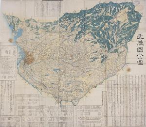
Complete Map of Musashi province
(Illustrated map)
This is a map of the 22 counties of Musashi Province. Rivers, marshland, and the ocean are drawn in blue, mountainous areas in green, and the confines of the city in deep colors to distinguish from the outskirts. Also, in the blank space an explanation of place names, a brief history, a list of temples and shrines, and a list of famous spots of Musashi Province are noted. Musashi Province is a large region that covers the present day Tokyo Metropolis, Saitama Prefecture and a large portion of Kawasaki City and Yokohama City in Kanagawa Prefecture. Initially Musashi Province was formed from the 19 counties of Toyoshima, Ebara, Tachibana, Kuraki, Tsuzuki, Tama, Adachi, Iruma, Hiki, Yokomi, Saitama, Ohsato, Obusuma, Hara, Hanzawa, Naka, Kodama, Kami and Chichibu. However in the 8th century, the Koma County and the Shiragi County (which later became the Niikura County) and in the beginning of Edo period, a part of the Katsushika County of Shimōsa Province were integrated to make 22 counties. The artist of this picture, Hashimoto Gyokuransai, is the name the Ukio-e master Utagawa Sadahide used when he drew maps and his forte was for bird's eye view drawings.